| Modified: |
|||||
| Archaeological Research at Haft Tappeh | |||||
| Deutsch | |||||||||||||||||||||||||||||||||||||
| Geographical Situation | History of Research | Historic Overview | Current Project | Bibliography | |||||||||||||||||||||||||||||||||
|
Recent Research Activity
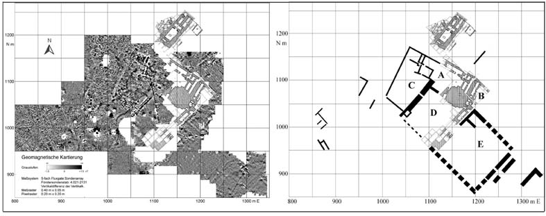
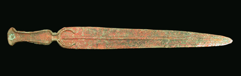
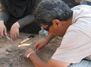
Goal of the project The Haft Tappeh project’s target is to restore and to preserve the monuments that were excavated in the seventies of last century. It furthermore wants to obtain new insight on the antique city and its role within the history of this region through new surveys and excavations. Research The former museum of Haft Tappeh was renovated and furnished as a project base with a laboratory, a tablet room, computer room and library (Fig. 1). In a first step all artefacts of the former excavations that were treated very badly had to be put into a systematic order and had subsequently to be analyzed. So far pottery vessels, figurines/statues, fragments of murals, bronze objects, sealing and tablets have been categorized and documented, which have been studied and published or are going to be investigated (Mofidi-Nasrabadi 2011a). In order to get a more detailed overview of the total structure of the city and its extension B. Mofidi-Nasrabadi carried out with a team of geophysicists of the University of Kiel geophysical prospection in autumn 2002. This Research was financed by the „Forschungsverbund Archäologie“ of the University of Mainz. In this prospection an area of 8,5 hectares was measured. Surprisingly in the course of this activity several monumental complexes with extremely wide walls were determined. They showed on the geophysical maps as weak anomalies (Mofidi-Nasrabadi 2003-04). Based on the geophysical maps of 2002 Mofidi-Nasrabadi started in 2005 a new expedition from January to February and the second campaign took place in October 2005. Again geophysicists from the University of Kiel were part of the research team that mapped the historical area with the geomagnetic and geoelectric methods. The geomagnetic method was used to map still a larger part of the historic site. The geoelectric method helped to a better understanding of the individual buildings. For stratigraphic purposes several deep ditches were made in selected areas. Besides pottery some interesting objects like two daggers and a bronze sword as well as statues and tablet fragments were found that are now kept in the museum of Haft Tappeh (Fig. 4). Between December 2006 and February 2007 the third excavation campaign took place, which resulted in the finding of the large part of an administration building of the 14th century BC. During the excavations further vast areas of the antique city were mapped in cooperation with the geophysics department of the University of Kiel implementing the geomagnetic method. These new measurements showed more monumental constructions within the city area. On the basis of the financing of the project by “Deutsche Forschungsgemeinschaft” for other three years it was possible to carry out other three campaigns in autumn 2008, spring 2009 and spring 2010. The excavations took place in the complex C in the northern part of the city as well as in the south part near the administration building..
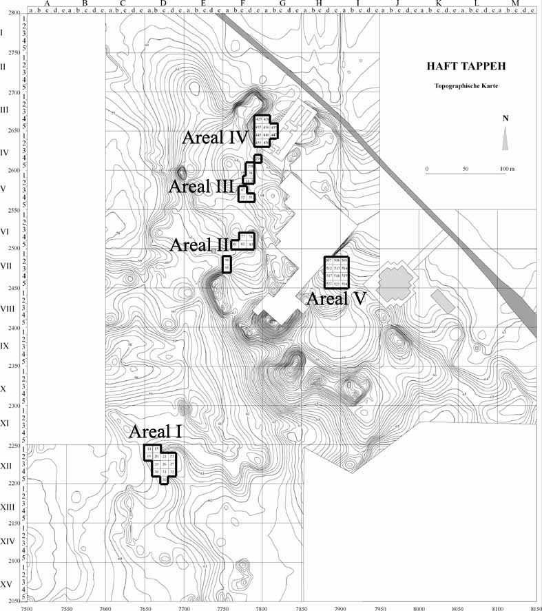
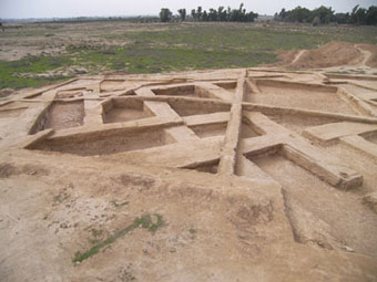
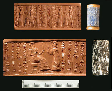
Results Based on the geophysical maps we were able to determine five monumental complexes apart from the tomb building excavated by Negahban in 60s (Fig. 2, A-E). They include large courtyards surrounded by rooms. Their outer walls are very strong and can be to about 10 m wide and 100 m long. The complexes A and D are close to the terraces which were excavated by Negahban (Mofidi-Nasrabadi 2003-04). In order to clarify the function of the complexes and the chronological relationship between them, we carried out excavations in five areas (Fig. 3, area I-V; Mofidi-Nasrabadi 2010, 2012c, 2014). In area I which is situated in the south part of the city, we found an administration building (Fig. 5) with archives of inscribed tablets (Fig. 6). The building included besides a workroom for scribes also several long rooms constructed parallel to each other for storing valuable objects (Mofidi-Nasrabadi 2012a). The scientific research of these tablets carried out by D. Prechel shows that they were mainly inventories listing objects like arrows, quivers, artifacts from gold and silver, harnesses and riding equipment etc. (Prechel 2010). Furthermore there are also lists of functionaries and letters that their translation is in preparation. Because of ash layers in several rooms and the remains of burned roof beams the building must have been destroyed by a fire. In a house situated on the southeastern part of the administration building we found in a room an interment in a sarcophagus which obtained two seals among the grave goods (Fig. 7). The inscriptions of the seals indicate that the seals belonged to a person named Ginadu with the title “puhu-teppu of the king Inšušinak-šar-ilani” (Mofidi-Nasrabadi 2011b). The puhu-teppu should be the title of a high ranked functionary who was responsible for inventory and custody of the objects in the storage. Most probably Ginadu worked in the adjacent administration building during the reign of Inšušinak-šar-ilani. The pottery found in the administration building and the inscriptions confirms this dating, because they belong to the first phase of the Middle Elamite period. It could be assumed that the administration building was built and used in the period of the reigns of Inšušinak-šar-ilani and Tepti-ahar about the end of fifteenth to the beginning of the fourteenth century B.C. It seems that both rulers reigned successively, because there are a few personalities who appear to have lived during the reign of both of them (Mofidi-Nasrabadi 2013). Shortly after its destruction the administration building was used as a burial area. The dead bodies were either buried in sarcophaguses, big vessels, or simply in the earth. The burials must have occurred in the time following its devastation. So they were dug into the fill of the building after its destruction. In the area III our work was focused in the northern part of the complex C, which was distinguished through geomagnetic prospection. Based on the excavations we were able to distinguish at least three building levels from the Middle Elamite period. Furthermore there was an anterior building level dated in the Sukkalmah period in the area IV on the northwest side of the tomb building which was excavated by Negahban. So the excavation in different areas asserted that there were at least four building levels from different Elamite periods as follows:
Building level I …. Sukkalmah period (Beginning of the second millennium B.C.) Building level II … Middle Elamite period (End of the 15th to the beginning of 14th century B.C.) Building level III ... Middle Elamite period (14th century B.C.) Building level IV ... Middle Elamite period (End of the 14th to the beginning of 13th century B.C.)
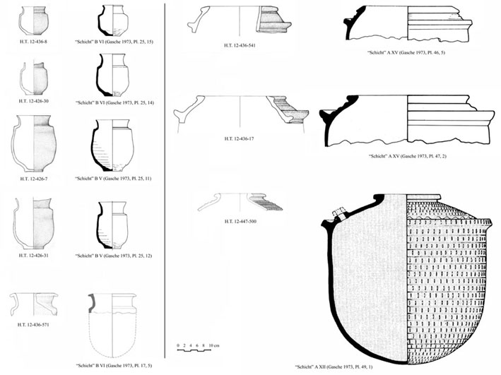
The eldest pottery in Haft Tappeh from the building level I is similar to the pottery exemplars from Susa in the so called “layers” of Ville Royale B VII – B V and A XV – A XIII (Fig. 8). For as much as possible precise chronology we undertook radiocarbon dating of 25 samples which after evaluation will be published. An interesting discovery appeared 2012 behind the north eastern outer wall of the complex C in the street between the complex C and the tomb building. There were amassed several hundred skeletons over each other behind the wall. Based on the number of skulls we excavated 149 individuals. In the unexcavated part of the trench it should be other 100 to 150 skeletons. Some of the skulls and bones seem to belong to children. Between the skeletons we found some pottery vessels from the Middle Elamite period. Also some date kernels were found. Although there is no indication for an ordinary burial, but it seems that some people tried to give the deceased scarce nutriment as grave goods. The large number of deceased led to the assumption that there took place either a massacre or an epidemic. The position of the skeletons indicates that they were amassed behind the wall at the end of the building level IV (Mofidi-Nasrabadi 2014). |
|||||||||||||||||||||||||||||||||||||
.jpg) |
|||||||||||||||||||||||||||||||||||||
| Fig. 1: The Project Center | |||||||||||||||||||||||||||||||||||||
 |
|||||||||||||||||||||||||||||||||||||
| Fig. 2: Excavation Plan and the Magnetogramm (after Mofidi-Nasrabadi 2014, Fig. 1) | |||||||||||||||||||||||||||||||||||||
 |
|||||||||||||||||||||||||||||||||||||
| Fig. 3: Topographic Map and Excavation Areas at Haft Tappeh | |||||||||||||||||||||||||||||||||||||
 |
|||||||||||||||||||||||||||||||||||||
| Fig. 4: Bronze Dagger | |||||||||||||||||||||||||||||||||||||
 |
|||||||||||||||||||||||||||||||||||||
| Fig. 5: Administration Building | |||||||||||||||||||||||||||||||||||||
 |
|||||||||||||||||||||||||||||||||||||
| Fig. 6: Tablet from Haft Tappeh in situ | |||||||||||||||||||||||||||||||||||||
 |
|||||||||||||||||||||||||||||||||||||
| Fig. 7: Cylinder Seals of Ginadu | |||||||||||||||||||||||||||||||||||||
| Haft Tappeh | Susa | Haft Tappeh | Susa | ||||||||||||||||||||||||||||||||||
 |
|||||||||||||||||||||||||||||||||||||
| Back to Home | |||||||||||||||||||||||||||||||||||||
|
(C) 2004 B. Mofidi-Nasrabadi
|
|||||||||||||||||||||||||||||||||||||
| Fig. 8: The Pottery from the Building Level I at Haft Tappeh compared to the Pottery from Susa (after Mofidi-Nasrabadi 2014, Fig. 13) | |||||||||||||||||||||||||||||||||||||
| The Reconstruction of the Archive Room | |||||||||||||||||||||||||||||||||||||