TROPICAL CYCLONES’ IMPACT ON THE MIDLATITUDES

When tropical cyclones move into the midlatitudes they often undergo “extratropical transition” (ET), i.e. they gradually lose their tropical characteristics and may transform into an extratropical low pressure system. The impact of the tropical cyclone on the synoptic-scale circulation in the midlatitudes can be significant. ET may excite Rossby wave packets that then disperse along the midlatitude jet stream. By this mechanism the impact of ET can reach near-hemispheric scales. Severe weather events have been linked to upstream ET systems. Frequently, predictability is severely compromised downstream of an ET system. The potential for severe weather to occur in regions of reduced predictability highlights the importance of achieving a better understanding of the physical processes that govern the downstream impact of ET.
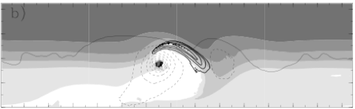

Potential temperature (θ) on the dynamic tropopause (2 PVU surface, color), surface pressure (thin contours, every 5 hPa, dashed for 990 hPa and less), and wind speed at 200 hPa (thick contours, every 5 m/s, starting at 45 m/s). The initially zonal jet stream is located along the gradient of θ on the tropopause. The distinct minimum in surface pressure denotes the ET system. Very high θ values (white) indicate the outflow anomaly. The jet streak downstream of the ET system is evident and the wave-like pattern shows the developing ridge-trough couplet. A first indication of the “PV streamer” can be found on the eastern flank of the outflow air. (Fig. 2(b) from Riemer et al., 2008)
We have investigated the excitation and dispersion of Rossby wave packets in numerical experiments of idealized ET scenarios. Piecewise inversion of potential vorticity, complemented with a Helmholtz decomposition of the flow, has been applied to quantify the impact of ET on the midlatitude circulation. Interacting with a straight jet the characteristic impact of ET is the formation of a ridge-trough couplet with a distinct jet streak in-between. Rapid cyclogenesis ensues in front of the downstream trough underneath the left exit region of the jet streak. The ridge-trough pattern then extends downstream as a wave train. The propagation characteristics of the wave train depend on the strength of the jet stream.
The ET system has a profound impact on the evolution of the ridge-trough pattern over an extended period of time. First the divergent outflow of the tropical cyclone is the most important contributor to ridge building. Later on the balanced cyclonic circulation of the ET system plays a significant role also. The balanced outflow anticyclone may promote phase-locking between the developing upper-level wave and the ET system, amplifies the downstream trough, and finally contributes to the anticyclonic breaking of the trough and to the formation of a PV streamer. In our experiments the ET system can be regarded as a long-lived local wave maker. Through this analogy it is clear that the structure and evolution of the ET system can have a significant impact on the downstream evolution. Arguably a correct representation of the ET system - a challenge for current numerical weather prediction models - is of crucial importance not only for the forecast of ET itself but also for increased predictability of the downstream flow.
(For more comprehensive information please refer to Riemer, Jones, and Davis 2008 and Davis, Jones, and Riemer 2008)


Integrated advection of θ (in K km2/s) into the crest of the ridge adjacent to the rapidly developing cyclone downstream of ET as derived from piecewise PV inversion and diagnostic of the divergent wind. Light grey denotes contributions from the upper-level wave itself (barotropic wave propagation), medium grey denotes the impact of the divergent flow, and black denotes baroclinic feedback from the low-level anomalies. Negative values denote ridge amplification. The time into the experiment is given on the x-axis (left: baroclinic-wave-only, right: ET scenario). In the ET scenario, a continuous impact of barotropic wave propagation is evident. Furthermore, the divergent impact (due to low-level diabatic processes) is prominent in the early stage of ridge building already. In contrast, the evolution in the baroclinic-wave-only experiment follows the concept of downstream baroclinic development. Barotropic wave propagation is dominant early, subsides later on, and exports energy away from the high-amplitude ridge at 144h. Baroclinic feedback and indirect diabatic amplification contribute most significantly during the second half of the amplification. (Fig. 11 from Riemer and Jones, 2010)
A straight jet is a highly simplified representation of the midlatitude flow. We thus considered a more realistic, albeit more complex ET scenario also. In this scenario ET takes place in a developing baroclinic wave that has been excited by a localized upper-level perturbation. The ET system is then no longer the only perturbation but competes with midlatitude forcing. The direct impact of the ET system is similar as in the straight jet scenario: the formation of a high-amplitude ridge-trough pattern and a jet streak, and enhanced cyclogenesis downstream. The formation of the ridge adjacent to the intensified downstream cyclone has been analyzed in detail to elucidate the next stage in the downstream dispersion of the ET impact. Ridge-building in the ET scenario exhibits characteristics distinct from those in the baroclinic-wave-only experiment. Wave breaking, feedback from the modified low-level frontal structure and diabatic processes all contribute to the high-amplitude wave pattern downstream of ET.
Further experiments show that the sensitivity of the ET evolution can transfer into the downstream region and change the characteristics of the downstream impact. The most widespread and rapidly propagating impact is found when the ET system interacts with the leading edge of the baroclinic development. We thus speculate that this leading edge represents an optimal location of the midlatitude circulation where ET can lead to the most significant impact on the downstream flow.
(For more comprehensive information please refer to Riemer and Jones 2010)

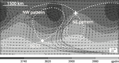
Topology of the steering flow pattern, representative of the times before significant straining of the upstream trough occurs. The wind field in the frame of reference moving with the baroclinic wave is depicted by arrows. The dashed, white lines denote the hyperbolic manifolds of this flow, i.e. the streamlines emanating from the hyperbolic stagnation points (marked by the dot and the cross). The geopotential (shaded) is shown for reference. The thin black lines denote the tracks of the ET systems in the frame of reference moving with the wave. The hyperbolic manifolds give a reasonable indication of the three different track regimes in our set of experiments, denoted as ‘NW pattern’, ‘NE pattern’ and ‘no ET’ in this figure (see text for further explanation) (Fig. 11 from Riemer and Jones 2013).
The interaction of a tropical cyclone with a high-amplitude, upper-level wave constitutes a contrasting scenario to the developing baroclinic wave. Introducing a waviness metric, we find that ET yields an even further amplification of the high-amplitude wave pattern. The amplification, however, leads to wave breaking and thus a coherent, amplified wave train in the farther dowsntream region is not obvious. Instead, subsequent wave breaking initiates the deamplification of the downstream flow. A more detailed analysis shows that straining due to the cyclonic circulation plays the most important role in the initiation of wave breaking in this scenario.
As in previous studies, the evolution of ET exhibits large sensitivity to the initial location of the tropical cyclone. Examining the steering flow’s topology, i.e. identifying the stagnation points and the streamlines emanating from these points, helps to identify three different regimes: a no-ET regime and two ET regimes reminiscent of the northwest and northeast patterns, respectively, introduced previously by Harr et al. (2000). A stagnation point located on the axis of the upstream trough governs the bifurcation into no-ET and ET regimes. A stagnation point located on the axis of the downstream ridge governs the bifurcation into northwest and northeast patterns.
(For more comprehensive information please refer to Riemer and Jones 2013)
In Riemer and Jones (2010), we identified the development of the downstream cyclone as an important step in the downstream dispersion of ET‘s impact. We thus examined this important aspect in more detail (Riemer et al. 2014). Specifically, the hypothesis was tested that the amplified jet streak downstream of ET - an archetypical feature in the real atmosphere also - plays a prominent role in downstream cyclogenesis. This hypothesis seemed reasonable because the jet streak during ET is partly forced `externally' and is not merely part of the inherent baroclinic development. The relative importance of the jet streak, as compared to the upper-level trough, was investigated by using the Q-vector partition introduced by Jusem and Atlas (1998). This partition is based on flow geometry and yields 1) a curvature terms that can be attributed to trough-ridge patterns and 2) stretching and shear-advection terms that can be attributed to jet streaks. To increase the accuracy of the analysis in the vicinity of considerable curvature, we extended the framework from quasi-geostrophic theory to Alternative Balance. The individual terms are illustrated below.
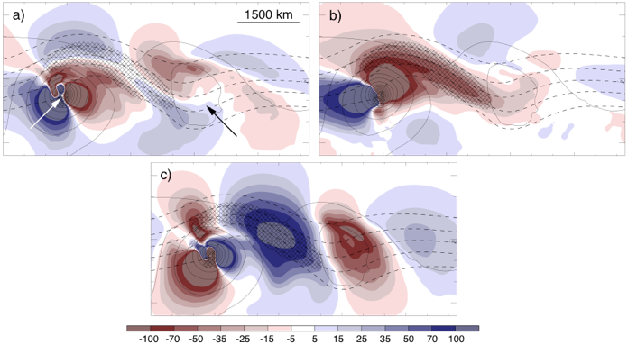
Individual contributions to vertical motion (shaded, on 500hPa, in mPa/s) during downstream cyclogenesis in the idealized experiment with a straight jet of Riemer et al. (2008). White and black arrows in a) highlight the ET system and the developing downstream cyclone, respectively (solid contours denotes surface pressure, every 5hPa). Hatching indicates the jet streak and dashed contours the streamfunction near the tropopause. a) and b): Stretching („four-quadrant model“) and shear-advection („Shapiro-effect“) contributions attributable to the jet streak. c) Curvature contribution attributable to the trough. Ascent in the region of the developing cyclone is taken as an indication of the respective contributions to cyclone spin up.
We examined the idealized ET scenario with a straight jet (Riemer et al., 2008) and three real cases. In all cases, the trough played a prominent role in cyclone development. The jet streak played a prominent, favorable role for cyclogenesis in the idealized ET scenario and in one real-atmospheric case. In contrast, the role of the jet streak was clearly of secondary importance in another real case. Interestingly, in the third real case, the jet streak had a prominent but detrimental impact. It was concluded that amplified jet streaks associated with ET have the potential to be of significant importance for downstream cyclone development. The few cases considered in Riemer et al. (2014), however, pointed to a large case-to-case variability of the role of the jet streak.
An interesting aside of this study was that diabatic heating terms from the unique “Year of Tropical Convection” data set (Waliser et al., 2011) were used to examine the impact of diabatic processes on mid-tropospheric vertical motion. Diabatic processes in the considered cases acted mostly to amplify and localize updrafts within the envelope of rising air associated with adi- abatic, balanced dynamics. For a one-day period in one particular real case, however, vertical motion associated with latent heat release decoupled from the dry dynamics. Our brief analysis of this case supported the previous hypothesis by Grams et al. (2013a) that the associated cyclone exhibited characteristics of a diabatic Rossby vortex during this time.