| Modified: |
|||||
| Archaeological Research at Chogha Zanbil | |||||
| Geographical Situation | History of Research | Historic Overview | Current Project | Bibliogrphy | Contact | Deutsch | |||||||||||||||||||||||||||
|
Project
Goal of the research The main question to be answered concerns the city structure. It has to be clarified whether besides temple and palace complexes residential areas or other buildings with different function can be identified. Concerning the structure of the whole city it is still unclear what kind of interaction existed between those parts of the city that were built according a plan and those that emerged later as the so called “self grown” areas. In order to determine those, a more in-depth knowledge about the urban elements of the city is necessary. The structure of the residential areas, the course of the streets and the situation of market places should therefore be analysed more closely.
Method The study was carried out with the following methods: a) Documentation of visible construction remains b) Systematic surveys of construction remains found on the earth surface c) Geophysical measurement of the city area d) Excavation e) Surveys of the city’s periphery
Research Activities
a) Documentation of visible construction remains Remains of the building structure can very often already be observed on the earth surface level within the city area. The remaining walls consisting of baked brick fragments which have been preserved quite well until today testify that a large area within the city possessed constructions. The traces of these buildings are so evident that the registration and documentation of these house structures is easily feasible for many of them. This was a good opportunity to register a big part of the structure of the residential area and to establish a detailed map of these visible remains. This task was started in autumn 2000.
b) Systematic surveys of construction remains found on the earth surface Besides the registration of architectural remains, a systematic analysis of surface findings was carried out. Those objects were mostly pottery sherds, stone artefacts, spindle whorls, fragments of terracotta figurines. However the pottery artefacts outweigh those made of stone. The distribution of pottery sherds within the city area varies greatly. The largest amount of pottery sherds can be found on the south eastern side of the city area. For the systematic analysis of surface findings, the whole city area was divided in squares of 50 × 50 m. The analysis of the surface findings and the analysis of the research concerning architectural remains complement each other. This study is in preparation and will be published soon.
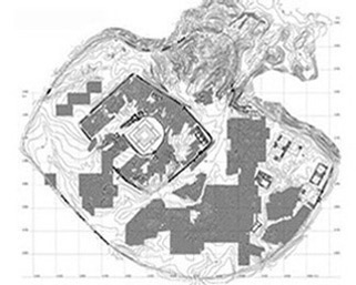
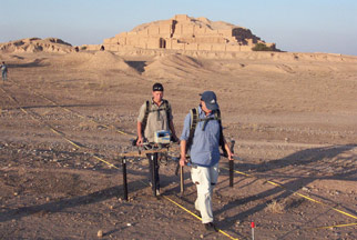
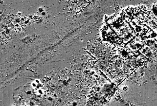
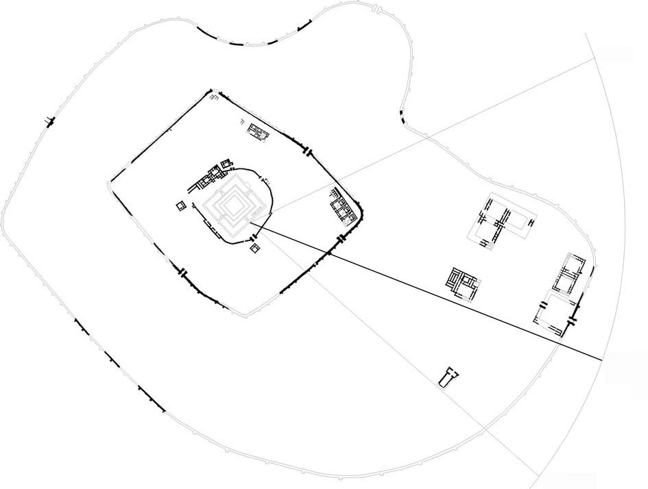
c) Geophysical measurement of the city area The geophysical measurement permitted a detailed analysis of the architectural structures and their functions within the city as well as the distribution of certain buildings and their reciprocal relationship. In autumn 2002 and 2003 and spring 2005 B. Mofidi-Nasrabadi carried out a geophysical prospection with a team of geophysicists of the University of Kiel. These expeditions had a duration of 2 weeks and were financed by the “Forschungsverbund Archäologie” of the Johannes Gutenberg University of Mainz and the Iranian Cultural Heritage Organization. 34 Hectares were measured by this method in Chogha Zanbil. The activities were concentrated on the so called Temenos and the south eastern part of the inner city area, because the surface findings were indicating a dense population of this area. Furthermore some areas to the Southwest or Northwest were measured. The result of these prospections was that a much larger part of the city had been populated than expected. Besides smaller building structures that can be identified as residential areas, there were also larger constructions. The strong registered contrast on the maps that resulted from the prospection indicated that baked bricks or baked brick fragments had been used for construction. The majority of the structures are presumably from the most recent period of the city life in the beginning of the 1st millennium B.C.
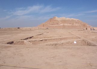
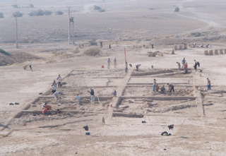
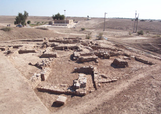
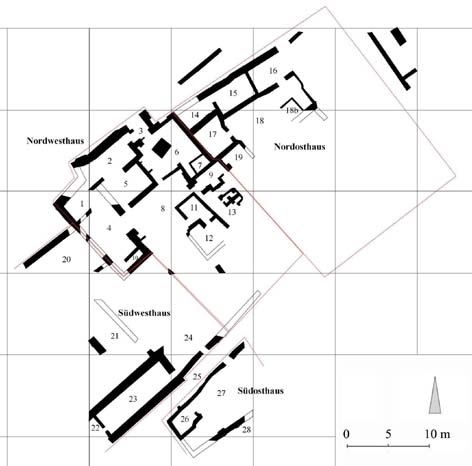
d) Excavations In addition to the above mentioned survey, excavations were carried out in the southern and south eastern part of the area within and outside of the middle wall. The target of these excavations was to get a more detailed image of the up to then unexplored parts of the area within the middle wall. In winter 1999 we chose to excavate the area to the southeast outside the middle wall. In two other excavation campaigns in autumn 2001 and spring 2002 two areas in the south within the middle wall were excavated. In all of those areas we were able to detect housings that belong to three different phases. They are not from the time of city foundation and built later. The main part of them is dated in the 1st half of the 1st millennium B. C. (B. Mofidi-Nasrabadi 2007).
e) Surveys of the city’s periphery An analysis of the city structure and the different functional entities completes the research activities started in 1999 that aimed at clarifying the settlement structure in the periphery of the city area. The result was that within a radius of maximum 1 km outside the outer city wall settlements could be identified and their relationship to the city within the various periods could be explained. The result of this study was published in AMIT 2003-04 (B. Mofidi-Nasrabadi 2003-04).
Results
The field works were carried out in order to obtain more information about the different structural features and the social aspects of the city. The gathered data are arranged in two parts. The first part regards the planned monumental buildings and their features which were published (Mofidi-Nasrabadi 2013). The second part is in preparation and discusses the residential areas and their chronology in order to understand better the social organisation of the city. In this analysis all results of the surveys, excavations and geophysical prospections and the entire pottery assemblage and other artefacts will be studied. For drawing a conclusion concerning urban space and social organisation the whole information must be taken into consideration. For the time being, it can be ascertained that the housings in the area of the middle wall (Temenos) are not from the time of city founding and were built in the following centuries. Based on stratigraphic relationships three following phases were determined during our excavations (B. Mofidi-Nasrabadi 2007): Building level 1 (8th and 7th century B.C.) Building level 2 (10th and 9th century B.C.) Building level 3 (12th and 11th century B.C.)
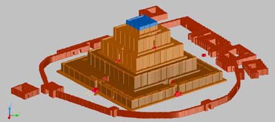
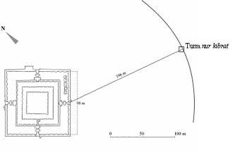
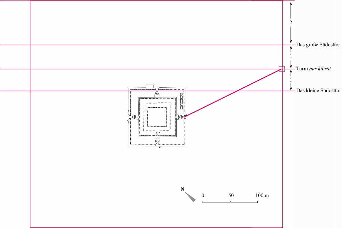
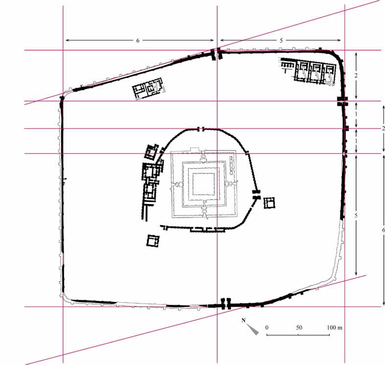
Planning of the city The city was conceived as a religious centre. So the economical factors, which were essential for the development of the city, remained out of consideration. The factors like road network, arable land, and canalisation played any important role by choosing the place for the new foundation. Although the Dez River ran near the city, it was not possible to use its water via a canal, because the city was built upon a ridge about 40 m higher. Making a canal of 45 km from Karkheh River, as proposed by Ghirshman, could also not have been realized, because of morphological features of the area. The city was built on the highest point compared to its surrounding region. Hence the particular sacral aspect must have been the main motivation of the king Untaš-Napiriša to build a new city. This fact is mentioned explicitly over and over again in the inscriptions and is demonstrated through building a monumental ziqqurrat (temple tower) and numerous temples. During the planning phase, the ziqqurrat played a central role. In order to realize the plans of ziqqurrat and other monumental building in the field, the Elamite architect used the principals of mathematic and geometry. The unit for measuring the construction dimensions was the mud brick format. So the dimension of the building was generally equal of a round number of bricks, like 30, 40, or 50. For the ziqqurrat we can observe an order of brick number by terraces in their measurement lengthwise, which is based on the sexagesimal system. The ziqqurrat’s core was built from mud brick and the terraces had the following scheme of brick number: High Temple …….. 36 bricks …… (1 × 6 × 6) Fourth Terrace …... 72 bricks …… (2 × 6 × 6) Third Terrace ……108 bricks ....… (3 × 6 × 6) Second Terrace … 144 bricks ….... (4 × 6 × 6) First Terrace ……. 216 bricks …… (6 × 6 × 6) This core of mud bricks was subsequently enveloped with a cover of backed bricks. After the position of the ziqqurrat and its dimension was determined in the field, the architects used its position in order to establish the direction and distance of the wall of the holy area. For this the southeast side of the ziqqurrat, which was the sunshine side, played the main role, because the entrance of the ziqqurrat at this side must have been the place for carrying out the so called sit Šamši-ritual at the moment of sunrise. This ritual most probably could have taken place in spring at the beginning of New Year. Beginning with the position of the ziqqurrat entrance at the southeast side, a tower was built in a distance twice longer than the ziqqurrat side in a place that the sun rose at the beginning of spring. Hence the tower was called nur kibrat (light of the universe) on its inscribed backed bricks. The tower was used as reference point for the distance between the middle wall and the ziqqurrat on the south eastern side. The wall was built parallel to the ziqqurrat and the positions of the gates were established in equal distances. The holy area had a rectangular form, while on the northeast and southwest sides there was a little derivation, because of ravines in those places. As argued above and also as the inscriptions show, the city was founded primarily as the residence of the divinities. Therefore the secular buildings, and in contrast to Mesopotamia even the palaces, were situated outside the holy area. The separation between the holy area of the divinities and the residential area of the human beings was emphasized through a strong wall. The ziqqurrat was furnished also with an extra wall, since it was the holiest place in the city. In this manner the plan of the city obtained a hierarchical division between holy sphere and the rest of the city. This separation was not followed by the citizens in the course of time, so that in the next centuries the people built their houses in the holy area. (For more information see Mofidi-Nasrabadi 2013). In the course of time some modifications took place on ziqqurrat and other buildings. The area around the ziqqurrat rose in the next centuries because of sedimented soil material. This fact can be observed well in different parts e.g. on the west corner, where a drainage canal originally was built below the inner wall and today is situated about 30 cm under the present pavement. So the current backed brick pavement should be from an earlier period. Also the gates were subjects of modifications over the centuries, so that different building stages can be distinguished for them (Mofidi-Nasrabadi 2007 and 2013).
|
|||||||||||||||||||||||||||||||||
| 3D Reconstruction of the Ziqqurrat | |||||||||||||||||||||||||||||||||
 |
|||||||||||||||||||||||||||||||||
 |
|||||||||||||||||||||||||||||||||
| City Area with Geomagnetic Prospection | |||||||||||||||||||||||||||||||||
 |
|||||||||||||||||||||||||||||||||
| Geomagnetic Prospection (Autumn 2002) | |||||||||||||||||||||||||||||||||
 |
|||||||||||||||||||||||||||||||||
| Magnetogramm | |||||||||||||||||||||||||||||||||
 |
|||||||||||||||||||||||||||||||||
| Southern Part of the Temenos | |||||||||||||||||||||||||||||||||
 |
|||||||||||||||||||||||||||||||||
| Excavated Area in the Temenos (2001) | |||||||||||||||||||||||||||||||||
 |
|||||||||||||||||||||||||||||||||
| Hoses in the Southern Part of the Temenos | |||||||||||||||||||||||||||||||||
 |
|||||||||||||||||||||||||||||||||
| Excavated Area B in the Southern Part of the Temenos | |||||||||||||||||||||||||||||||||
| Planning Aspects | |||||||||||||||||||||||||||||||||
 |
|||||||||||||||||||||||||||||||||
| The Position of the Sunrise at the Beginning of Spring | |||||||||||||||||||||||||||||||||
 |
|||||||||||||||||||||||||||||||||
| The Situation of the Tower nur kibrat related to the Sunrise Position | |||||||||||||||||||||||||||||||||
 |
|||||||||||||||||||||||||||||||||
| The Position of the Different Gates | |||||||||||||||||||||||||||||||||
 |
|||||||||||||||||||||||||||||||||
| The Rectangular Form of the Temenos | |||||||||||||||||||||||||||||||||
| Back to Home | |||||||||||||||||||||||||||||||||
|
(C) 2004 B. Mofidi-Nasrabadi
|
|||||||||||||||||||||||||||||||||